Great Hikes in Kansas City and the Surrounding Area

Isn't Kansas Flat?
Sure, Kansas can be flat. But have you ever been to the Flint Hills? They don't call them hills for nothing. That being said though, this discussion isn't about the Flint Hills (as beautiful as they may be). This is about great hiking in the KC area (both sides of the state line).
I should note that I'm being very generous with my description of "KC area". Two of my favorites are in the metro area, while the other two are a short drive outside of town. (Within an hour and a half, depending on what side of the metro area one is coming from.)
Here are my favorites, in no particular order:

Swope Park
(No, You Won't Get Mugged There)
Yes, Swope Park tends to have a bad reputation. When I tell people I hike at Swope Park, about 80% of the time they'll question my sanity or suggest that I should be afraid to hike there. But frankly, you don't meet a lot of muggers in the woods, and the trails at this park are fantastic. They're actually mountain biking trails, and the Earthriders Trails Association (ERTA) in conjunction with the Kansas City Parks and Rec department have done a fantastic job of creating and maintaining about 10 miles of trails at the park. There are plans for a total of 18 miles of trails before they're done.
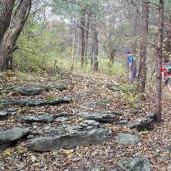
The trails are mostly wooded, and very scenic. Some sections are quite rocky, and pass through and around large rock formations. There are lots of ups and downs to provide a good workout. I prefer to start out on the WoodChuck Run (the more difficult trail), and stay to the right at every trail crossing, which eventually puts me on the Rancho D-Lux (the less difficult trail). Staying to the right at every crossing results in a large loop around the outside of the trails and a hike of approximately 7 miles. A good day's work, in my opinion.
Finding the trailhead can be a bit tricky. The trails are in the Camp Lake of the Woods area, and there is a sign on a gate by the trailhead that says "keep out", or some such thing. The sign is actually referring to vehicle traffic, but I know that it causes confusion for would-be hikers and bikers. Basically just take Oldham Road to Oakwood Drive. Turn onto Oakwood by the Camp Lake of the Woods sign, and park on either side of the road. Do not drive past the gate, even if its open. The trailhead is to the right of the gate.
Landahl Park - Blue Springs, MO
The downside to hiking at Landahl is that there's a firing range nearby. So hiking when the range is open is somewhat less than peaceful. I recommend this hike in the early morning before the range opens. However, the excellent trails more than make up for the disturbance caused by the firing range, so don't skip this hike just because you can't get there early enough.
There are about 9 miles of mountain biking/hiking trails here, and with names like Swedish Erotica and Rim Job, some of these trails aren't for the faint of heart. They'll get your blood pumping and make you wish you'd worn hiking boots rather than tennis shoes. But there are also many trails that offer an easier stroll, if that's what you're looking for. The trails are well marked, and a good map is available on the ERTA website.
I've posted a link to the trail map below, which also provides trail descriptions and directions for how to get to the park.
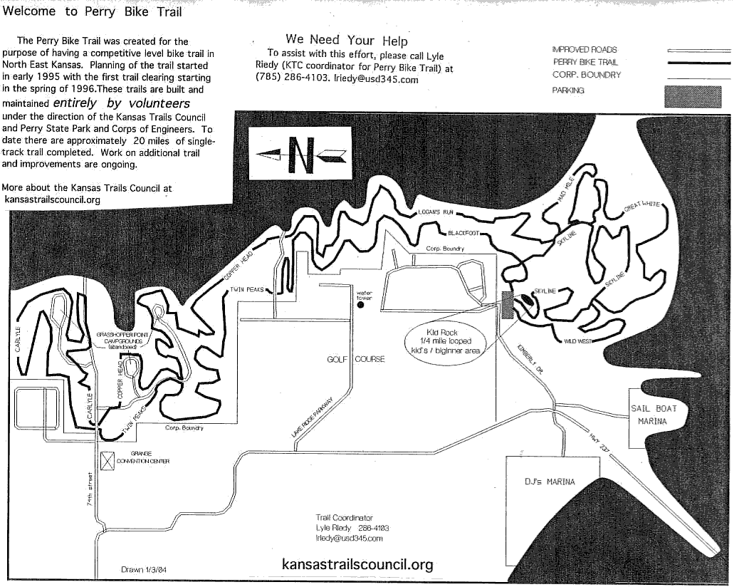
Lake Perry MTB Trails at Delaware Point
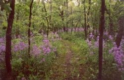
Perry Lake has two sets of trails. There's a 30-something mile set of hiking trails on the eastern side of the lake that I would only recommend in the wintertime. During the summer, it is a tick infested jungle of overgrown, hip-high weeds. There is some trail maintenance done on it, but not enough to keep it clear, unfortunately.
The good hiking at Perry is actually on the mountain biking trails in the Delaware Point area on the west side of the lake. There are over 20 miles of scenic trails, mostly wooded, with some lake views. Take note though that these trails do fall within the confines of Perry State Park, and as such are subject to a state park day use fee. I always buy an annual Kansas Parks pass, which pays for itself with just a few visits, thereby avoiding the day use fee every time I enter a Kansas State Park.
Like most mountain biking trails in this area, these trails are well marked, and have a variety of difficulty ranges. The most difficult of the trails can be very demanding, but extremely enjoyable. Trail maps are usually available at the trailhead, but I recommend downloading one before leaving the house, just to be on the safe side. There are enough trails going in various directions to get a little lost or turned around without a map.
For more info about these trails, see the Kansas Trails Council or Lawrence Mountain Bike Club websites.
Clinton Lake Trails
There are over 40 miles of trails at Clinton, but the one I prefer is the North Shore trail. There are 21 miles of trails that make up the North Shore Trail system, with trailheads in both the Corps of Engineers and State Park sections of the lake. The white trail is the more difficult trail, and meanders up into the woods, while the easier blue trail tends to hug the shoreline of the lake.
I recommend starting at the Clinton Lake Overlook, and taking the white trail out about six miles, then crossing over to the blue trail (there are many opportunities to do so). Since the blue trail stays close to the shoreline and doesn't wander into the woods too much, the total hike is about 10 miles if one hikes out on white, but returns on blue. There are various spurs that lead to campgrounds and parking lots, but its easy to stay on the main trails as they are well marked.
The trailhead and parking is just to the south of the Corps of Engineers visitor's center, and is easy to find. Trail maps aren't really needed since there are only two trails, and its almost impossible to get lost. However, I've included a link below for those who really like to have a map anyway.
More Trail Info
The Kansas Trails Council and a variety of local mountain biking clubs including the Lawrence Mountain Bike Club and the Earthriders offer lots of information on their website about local trails. I highly recommend checking out their websites (some links are below).
And please, if you do use these trails, be a good citizen of the trails. Pack out what you take in, don't use the trails when they're wet as it can damage them, and always yield to mountain bikers going uphill (because its polite and they're working their butts off).
Happy hiking!
Best Books on KC and Kansas Hiking
I own all both of these books, plus the one highlighted on the upper right, and highly recommend them as resources for finding the best hikes and making the most of your hike once you're there.


Links to More Info About These Great Places to Hike
- Swope Park Trails
Info about the Swope Park mountain biking/hiking trails - Landahl Park Trail Map
Trail map provided by Earthriders - Perry Bike Trail Map
Perry trail map provided by the KTC - Map of North Shore Trails
North Shore trail map provided by the KTC


